

Аннотация
Cadastral and geodetic land works are expensive, which makes aerial photography extremely valuable for land traceability and inventory. The present research objective was to develop a new digital survey technology for registration of agricultural lands. We assessed the accuracy of the new method and evaluated its decision support options. The study featured the case of the Kemerovo Region (Kuzbass), Russia.The aerial survey took place in 2021 and involved 17 municipalities of the Kemerovo Region. The software and hardware complex included an unmanned aerial vehicle (UAV) and a module for aerial photography. Photogrammetric, cartometric, and satellite methods were used to define the coordinates of feature points. We developed new software (Sovhoz.avi) to perform the land inventory.
The photogrammetric and cartographic methods proved efficient in determining the feature points and boundaries of land plots. They also appeared accurate enough for land inventory and decision support. The study updated the available land inventory data. About 30% of all land plots were recorded incorrectly; some plots marked as agricultural appeared to belong to the local forest reserves or urban territories. Incorrect data (1.64%) were excluded from the official inventory. The survey covered a total area of 41 000 ha and revealed 1700 illegally used land plots. The updated inventory of unused lands included 3825 new plots (163 400 ha), which can attract prospective investors.
The results can be used by the local authorities to make land management decisions and identify illegal land use.
Ключевые слова
Agricultural land, food, land inventory, unmanned aerial vehicle (UAV), aerial survey, illegal land useВВЕДЕНИЕ
The present research featured a new aerial survey software and hardware complex, which included a camera-equipped unmanned aerial vehicle (UAV) and digital twin software tailored for agricultural inventory. The new technology provided a digital account of agricultural lands in the Kemerovo Region aka Kuzbass (West Siberia, Russia). The article introduces an assessment of its accuracy and decision support options.
Food security remains one of the main global issues [1–3]. In fact, famine relief is one of the seventeen Sustainable Development Goals set up by the United Nations [4]. Stable food production and availability presupposes efficiency, land availability being the most important production factor in agriculture [5, 6]. Agricultural land depletion, shortage, and irrational use make it difficult to provide the growing world population with food [7–10]. Therefore, land-use efficiency is an important task of resource-intensive digital precision farming [11–13].
Agricultural land resources are limited. Therefore, their inventory and management require high-quality accurate information about the terrain, its configuration, location, etc. These data help plan agricultural work, calculate potential yields, make decisions on the allocation of machine time, seeds, fertilizers, etc. [14]. Accurate land survey is also vital for crop selection, rotation, and logistics [15]. If an agricultural land plot has a complex terrain and the current crop market conditions are unstable, a high-quality land survey can provide the maximal economic effect [16]. Obviously, agricultural organizations are interested in complete and detailed information about their land.
The poor quality of land data is a relevant agricultural issue in Russia and some other countries [17, 18]. As evidenced in practice, traditional paper maps are mostly inaccurate. They are out of date and fail to chart all the lands in actual agricultural use. For instance, a shrub-overgrown area can still be registered as fit for farming, with crops, seeds, fertilizers, and equipment operation time allocated for its cultivation. Land-use efficiency presupposes official registration, state inventory, and open access, which can prevent mining development of agricultural lands [19, 20]. Landuse efficiency ensures fair taxation, protects the interests of stakeholders, determines the required amount of state support, and assesses the main agricultural indicators. In addition, it enables small farmers and agribusinesses to use land as collateral for a bank loan.
Official state inventories often contain faulty or no data at all, which causes irrational use of agricultural plots and land law violations. Most of these problems result from the high cost of traditional geodetic and cadastral work. Traditional land surveys require a lot of man labor and high transportation costs. As a result, they can be too expensive for most agricultural enterprises [21, 22]. Many agricultural land users are not interested in geodetic investigations of their lands: they prefer to refrain from even one-time cadastral surveys, not to mention regular ones. Digital twins of agricultural areas can solve this problem. Visual data are gathered by UAVs and processed by specialized software.
Aerial surveys and drone-mounted infrared cameras are able to solve a wide range of tasks, e.g. maintaining linear infrastructure facilities, tracking forest fires, monitoring construction and mining operations, counting game population, looking for missing people, developing smart city projects, etc. [23–28]. UAVbased aerial surveys are cheap and require no physical presence on location, thus preventing subjective and objective human errors [29]. Therefore, the new complex increases the accuracy and reduces the cost of agricultural land surveys.
UAVs have become focus of numerous scientific publications on cadastral work and real estate inventory. For instance, Puniach et al. wrote about a UAV-based update of cadastral data on territories with frequent landslides [30]. The study covered an area of about 50 ha and involved a DJI S1000 octocopter, which hovered at 145 meters above the ground. A Sony ILCE A7R camera provided an 80% direct overlap and a 60% side overlap. It took 500 images and fixed 33 control points. The data were processed using Agisoft PhotoScan Professional, which determined a landslide with an accuracy of up to 0.5 meters. The research made it possible to update the cadastral database and support the farms affected by landslides. The study demonstrated acceptable accuracy in surveying small agricultural plots. In fact, some studies limit the cadastral capabilities of UAVs to small hard-to-reach areas [31].
Šafář et al. studied liDAR laser scanning as a means of updating cadastral records in the Czech Republic [32]. Their research involved a DJI Matrice 600 Pro hexacopter, a LiDAR RIEGL miniVUX-1, and PosPac software. The survey results met the local accuracy requirements. Even a partial use of UAVs in construction monitoring reduced their costs by 18–20%. However, the study, like most publications on this issue, focused on the cadastral registration of capital construction objects, not land plots [33, 34].
Brookman-Amissah et al. proved that UAV-based aerial survey determined boundaries of land plots with an accuracy stated by the legislation of Ghana, i.e. up to 3 ft, or 91.5 cm [35]. However, the research involved a lightweight UAV (430 g), which could perform only in the most ideal weather. The research provided no data on heavier commercial-grade UAVs. Thus, the problem of using aerial digital surveys for land inventory is at its initial development stage. It requires new methods for surveys and data processing on larger areas, as well as field tests in real weather conditions.
ОБЪЕКТЫ И МЕТОДЫ ИССЛЕДОВАНИЯ
The research featured agricultural land plots located in 17 municipal districts of the Kemerovo Region (West Siberia, Russia). The complex included two unmanned aerial vehicles (UAV): a cantilever highwing aircraft with a Lun 20 gasoline engine (Spetsialmiy Tekhnologicheskiy Tsentr LLC, St. Petersburg, Russia) and an all-wing drone with a Geoscan 201 electric engine (Geoscan, Saint-Petersburg, Russia). Their maximal takeoff weight was 18.6 and 8.5 kg, respectively. This research employed commercial aircraft-type UAVs, unlike previous studies that featured light helicopter-type drones. In good weather and with no vertical drops, a Lun 20 drone is able to survey an area of 20–55 km2 per flight, a Geoscan 201 drone – about 9 km2.
The Lun 20 carried a module for cartographic aerial photography, which included: a turntable to compensate for the wind drift, a Phase iXM-50 aerial camera (Phase One, Denmark), a Javad TRE-3N OEM board for tracking geographic coordinates (Javad GNSS Inc, USA), and a cloud assessment camera. The Geoscan 201 carried a Sony RX1R II digital camera (SONY, Japan) and a Topcon GNSS receiver (Topcon Corporation, Japan). High-precision dual-frequency GNSS receivers Javad Triumph-2 (Javad GNSS Inc, USA) and Trimble R10-2 (Trimble Inc, USA) provided on-ground horizontal and vertical control of geographic coordinates.
The software part of the complex was represented
by the Sovhoz.avi, a platform for digital inventory and
management of agricultural land. The software was developed at the Digital Institute of the Kemerovo
State University (Kemerovo, Russia). It stores aerial
photography data and those obtained from external
sources, e.g. official data on the agricultural land plots
obtained from federal, regional, and municipal sources.
The platform has been accumulating available data on
officially registered agricultural land plots since August
2020. The list of sources included:
– Federal Service for State Registration, Cadaster, and
Cartography (Rosreestr) – digital data on 35 000 sites
(2019);
– Ministry of Agriculture and Processing Industry of
the Kemerovo Region – digital data from the Unified
Federal Information System of Agricultural Lands
(2020);
– Committee for State Property Management of the
Kemerovo Region – paper documents on 26 000 land
plots (2020);
– Municipal Property Management Committees – digital
data on 13 000 plots from 17 municipalities of the
Kemerovo Region; and
– Municipal Authorities – digital data on 22 000 share
lands, federal lands, and plots under registration (2020).
The UAV aerial survey took place in 2021. It aimed at clarifying the available data, forming a unified database of agricultural land management, and identifying illegal land use. The study had several stages. The first stage included an on-ground horizontal and vertical control of geodetic coordinates using GNSS receivers in the RTK mode. After that, the results of aerial photography were linked to geographic coordinates (MSK-42 Zone 1, BSL 1977).
The second stage lasted from May 10 to September 16, 2021. Two teams used the Lun 20 and the Geoscan 201 to perform an aerial survey of agricultural lands. The equipment was checked and programmed a day before the survey, which was carried out on sunny and dry days with a lot of sunlight and moderate or no wind. The obtained nadir images with a pre-set forward and side lap made it possible to construct an orthophotomap and a digital terrain model.
The third stage included data processing for subsequent managerial decisions by the authorities and land users. This stage made it possible to justify the use of photogrammetric and cartometric methods as means of determining the geographical coordinates of land plots.
The present research used standard methods of computer science, probability theory, and mathematical statistics to compare the coordinates obtained by satellite geodetic (GNSS), photogrammetric, and cartometric (orthomosaic) measurements. The procedure followed the requirements of the Order of the Federal Service for State Registration, Cadaster, and Cartography (Rosreestr) dated October 23, 2020, No P/0393 “Accuracy and method requirements for determining the feature point coordinates of land plot boundaries and buildings contours”.
When it goes about agricultural land plots, the root mean square error (MSE) for determining feature point coordinates cannot exceed 2.5 m, and the pixel projection for aerial photographs should be 35 cm. However, this rule is not applied to private household plots, gardens, garages, and houses. To simulate unfavorable working conditions, the calculations were carried out for points with limited visibility and signal interference. The Agisoft Metashape software (Zhivoy Soft OOO, St. Petersburg, Russia) was used to compare the results of the photogrammetric and cartometric methods. This software in its professional edition determines the geographical coordinates using the photogrammetric method or an orthophotomap.
The MSE for the feature points were calculated by the following formula to compare the survey results obtained by different methods:
![]()
where D is the vector length between the feature point and base station point, mm.
The MSE for the location of the feature point of the contour σ, determined by photogrammetric method, was calculated as follows:
![]()
where σо is the MSE of the orthophotomap; σn it the MSE of the base station point; σc is the MSE of the control point.
The MSE of the feature point according to the cartometric method was calculated as follows:
![]()
The coordinates determined by various methods were tested for accuracy, and the data of the digital land survey were compared. After that, the results were studied for errors, inconsistencies, and violations.
РЕЗУЛЬТАТЫ И ИХ ОБСУЖДЕНИЕ
The new software and hardware complex conducted an aerial survey of agricultural land in the Kemerovo Region. The results were used to compare different methods of measuring feature points. In case of the photogrammetric method, the mean square error (MSE) was
![]()
This MSE did not exceed the regulatory requirements specified above. Tables 1–3 compare three methods as in the case of the Topki municipality. The difference between the feature point coordinates obtained by different methods (∆) was calculated based on the geodetic inverse. Table 1 shows that the difference between the results of satellite and photogrammetric methods stayed within 10 cm, as specified in the regulatory requirements. Table 2 compares the data obtained by satellite imagery and cartometrics.
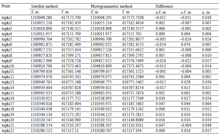
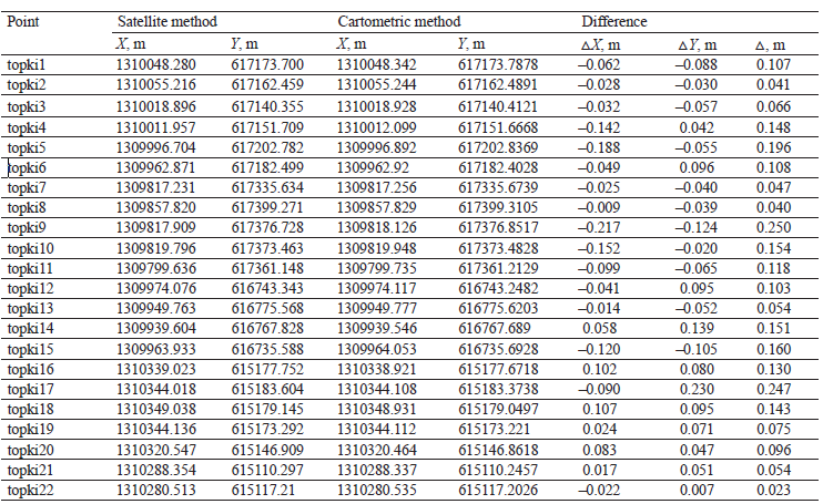
Table 2 demonstrates that the difference between the data obtained by satellite mapping and cartometrics was bigger than in the previous case and reached 25 cm. However, this MSE also stayed within the maximal allowable values. Therefore, the cartometric method proved sufficiently accurate, if compared to the satellite imagery, which served as control. Table 3 compares the data obtained by photogrammetric mapping and cartometrics.
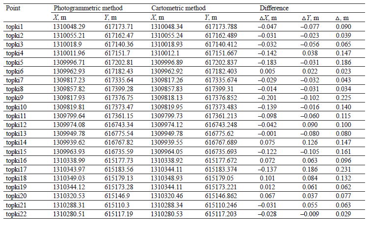
According to Table 3, the results obtained by cartometrics and photogrammetric mapping were very similar, and the MSE stayed within 25 cm. Therefore, a much cheaper aerial survey can replace traditional cadastral and geodetic works, as well as satellite imagery.
The next stage featured the Sovhoz.avi platform, which identified inconsistencies in the available data on agricultural land plots. The analysis involved software and visual control of data using the feature point coordinates of the land plots. The analysis of the data provided by the Federal Service for State Registration, Cadaster, and Cartography showed that the Kemerovo Region has a lot of agricultural land plots with unidentified boundaries. Their area is shrinking, but very slowly.
In 2017, there were 2.44 million ha of land with undetermined boundaries. In 2020, their area decreased by 22%, shrinking to 1.90 million ha. However, the total area of agricultural lands in the Kemerovo Region is about 2.9 million ha. Consequently, 65.5% of all agricultural land has unclear plot boundaries. This situation makes land-use efficiency and business turnover impossible. Moreover, it causes conflicts as it violates the legitimate interests of land users and renders faulty taxation.
The cadastral measuring of all agricultural land boundaries in the region costs 2.7 billion rubles, or 35 million US dollars (January 2022). Land users simply cannot afford it: in 2020, the total value of commercial products produced by agricultural organizations and farms of the Kemerovo Region was about 34.9 billion rubles. Thus, land users would have to spend about 7–10% of their annual revenue on cadastral work. Obviously, they would appreciate much cheaper digital methods.
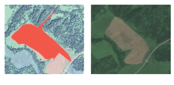
The Sovhoz.avi software also found some discrepancies in the data obtained from the Committee for State Property Management and the Ministry of Agriculture and Processing Industry of the Kemerovo Region. After 1200 paper maps were digitized, 30% of them appeared to be faulty to some extent. Figure 1 illustrates an example of such an error detected after comparing a digitized paper map with the aerial survey data.
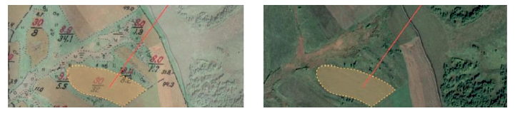
According to the paper map provided by the State Property Management Committee, the area of the land plot was about 32 ha. According to the coordinates obtained by the photogrammetric mapping, it was about 16.3 ha. This means that the land owner has to pay almost twice as much land tax while allocating extra resources to cultivate the acres that are not there. The error triggers incorrect agricultural work planning because most indicators, e.g. yield, are initially incorrect. The error occurred as the field partially overgrew with trees and shrubs. A prompt correction will allow the farmer to plan their costs, calculate their yields, and reduce their taxes.
The data on all previously recorded agricultural land plots were subjected to continuous automated control. This measure corrected numerous errors found in the data provided by the authorities. In the Izhmorka municipality, the survey revealed several agricultural plots (5189 ha) on the forest fund lands. The Ministry of Agriculture and Processing Industry of the Kemerovo Region misclassified them as agricultural. Figure 2 is a Sovhoz.avi screenshot which visualizes such an error that affected an area of 2352 ha.
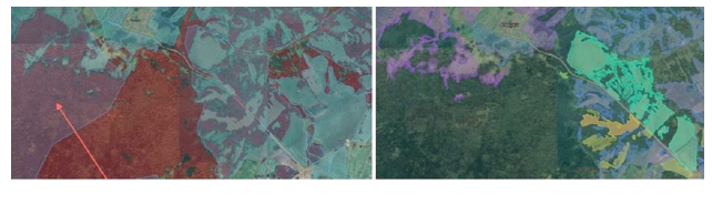
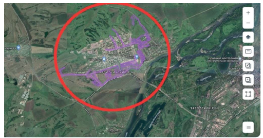
The red arrow on the left slide highlights the area that was classified as agricultural by the Ministry of Agriculture and Manufacturing Industry of the Kemerovo Region. However, the aerial survey on the right slide shows that this area is covered with forest. The data provided by the municipal authorities of the city of Novokuznetsk were subjected to similar control. The Sovhoz.avi platform identified several areas located in the city center and along the main highways that were mistakenly recorded as agricultural (Fig. 3, red circle). As a result, 670 land plots with a total area of 9144.96 ha were removed from the system.
The Sovhoz.avi platform currently contains data on 96 600 agricultural land plots with a total area of 2.4 million ha. After verification, about 0.04 million ha, which is about 1.64% of the total area, were excluded because the data were found unreliable. Since April 30, 2021, the platform has been used by the authorities and local governments of the Kemerovo Region. The users are mostly interested in such options as “view the plots”, “check and change boundaries”, and “check and change attributes”.
In May 2021, Sovhoz.avi was used to monitor the agricultural land use rights. Illegal use of agricultural land has become a relevant issue in the region as a result of incomplete and conflicting information, as well as a long period of no official control. Agricultural enterprises and individual farmers did not bother to obtain official permission when they decided to develop new plots, thus violating the fiscal interests of the state. In the end, farmers had neither accurate data on the size and configuration of their own lands nor any legal right to use them in transactions. The first stage of the monitoring revealed 688 plots (24 300 ha) with no official registration. While the agricultural profile of these plots was obvious from the aerial survey, the system lacked information about their state registration and permits.
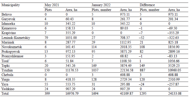
Of the initially identified 688 plots, 488 plots (65.1%, 15 300 ha) proved to be charted correctly. However, 34 plots (7.6%, 1100 ha) had to be inspected by specialists. The inspections revealed that all the plots were used for farming, e.g. animal sheds, barns, etc. The farmers were sent official recommendations to register their land plots. Table 4 illustrates the changes in the number and total area of illegally used land plots in 2021–2022.
Table 4 shows that the scale of illegal agricultural land use differs from municipality to municipality. The Tyazhin municipality is responsible for about 45.4% of the total area and 68.5% of the total number of illegal agricultural land plots. Its disadvantageous location and poor transport accessibility make any control a very complicated task. In some areas, e.g. in the Krapivino municipality, almost all illegal land plots were officially registered in 2021, while in other municipalities they were identified later.
The Sovhoz.avi software can also identify unused agricultural land plots. Agricultural land-use efficiency is vital for food security and agricultural development. Unused land plots can be offered to businesses that are interested in investing in the local agriculture. Unused land plots are very different. The Sovhoz.avi platform divided them into those that are easy or hard to introduce into agricultural use. The classification was based on two criteria deduced from the digital inventory data. The first criterion was the location of the plot in relation to settlements and roads. High transportation costs make hard-to-reach areas economically unviable. Therefore, easy-to-introduce areas are located near highways and settlements (Fig. 4), where farmers can hire workers, build warehouses and garages, etc. The second criterion is vegetation. Unused land plots get overgrown with shrubs and trees. Their uprooting is not cost effective. A field with trees and shrubs is difficult and inefficient to cultivate. Sovhoz. avi can identify trees and shrubs. Figure 5 illustrates another case of an easy-to-introduce land plot in the Novokuznetsk municipality.
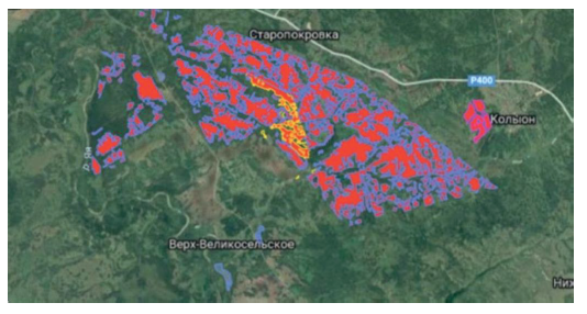
Areas with grass and trees are easy to spot (right slide) and measure (left slide, red area). The trees did not prevent Sovhoz.avi from identifying a country road that goes through the overgrown area. The monitoring revealed 3825 unused easy-to-introduce land plots with a total area of 163 400 ha and verified 1682 plots (44%) with a total area of 36 500 ha. These areas can be recorded in a separate inventory to be offered to potential investors.
Hard-to-introduce plots are far from highways and settlements. They are hard to cultivate because of trees and shrubs. Figure 6 gives an example of a hard-tointroduce land plot. The left slide shows field boundaries (highlighted) charted according to feature point coordinates. The dark green spots are trees and shrubs. The aerial survey (right slide) confirmed that the plot indeed belongs to those hard to introduce into agricultural use. It contains two birch groves, while its southern part is overgrown with shrubs. This plot would be very difficult to return to economic circulation.
The Sovhoz.avi platform revealed 29 140 hardto-introduce plots with a total area of 447 100 ha. Apparently, hard-to-introduce plots are much more numerous because all convenient plots are already in agribusiness. The platform verified 13 111 plots (44.9%) with a total area of 171 100 ha. These plots may return to economic circulation if the situation in agriculture and food market changes, e.g. prices and food demand continue to rise in 2022.
ВЫВОДЫ
The new aerial survey software and hardware complex, which included a camera-equipped unmanned aerial vehicle and the Sovhoz.avi digital twin software, proved to be an efficient and cheap means of agricultural land inventory. The digital inventory of agricultural land in the Kemerovo Region revealed numerous errors in the available official records. The most common errors included: unidentified boundaries (about 65% of all agricultural plots in the region), distortions of the geometric boundaries, and incorrect area calculation. Some plots located in urban areas or forest reserves were misidentified by the authorities as agricultural.
The aerial survey data and the Sovhoz.avi platform can provide local authorities with effective decisionmaking support. In January 2022, the Kemerovo Region had 1700 illegally used land plots with a total area of about 41 000 ha. The land users were recommended to register their land plots officially. The research also provided a new, updated inventory of unused agricultural land plots, which were divided into those easy or hard to introduce into agricultural use. Easy-tointroduce land plots have a good transport accessibility and no trees or shrubs (3825 plots with a total area of 163 400 ha). They form a promising reserve for the local agricultural development and can be offered to potential investors.
Вклад авторов
A.O. Rada supervised the research, set goals and objectives, edited the manuscript, and formulated the conclusions. A.D. Kuznetsov formulated the hypothesis, conducted the research, and wrote the manuscript.КОНФЛИКТ ИНТЕРЕСОВ
The authors declare that there is no conflict of interests regarding the publication of this article.ФИНАНСИРОВАНИЕ
The research was conducted on the premises of the Research Equipment Sharing Center of Kemerovo State University (KemSU), agreement No. 075-15-2021-694 dated August 5, 2021, between the Ministry of Science and Higher Education of the Russian Federation (Minobrnauka) and Kemerovo State University (contract identifier RF----2296.61321X0032).СПИСОК ЛИТЕРАТУРЫ
- Cooper M, Müller B, Cafiero C, Bayas JSL, Crespo Cuaresma J, Kharas H. Monitoring and projecting global hunger: Are we on track? Global Food Security. 2021;30. https://doi.org/10.1016/j.gfs.2021.100568
- Béné C, Bakker D, Chavarro MJ, Even B, Melo J, Sonneveld A. Global assessment of the impacts of COVID-19 on food security. Global Food Security. 2021;31. https://doi.org/10.1016/j.gfs.2021.100575
- Genkin AS, Mikheev AA. Influence of coronavirus crisis on food industry economy. Foods and Raw Materials. 2020;8(2):204–215. https://doi.org/10.21603/2308-4057-2020-2-204-215
- Vogliano C, Murray L, Coad J, Wham C, Maelaua J, Kafa R, et al. Progress towards SDG 2: Zero hunger in Melanesia – A state of data scoping review. Global Food Security. 2021;29(1). https://doi.org/10.1016/j.gfs.2021.100519
- Cintina V, Pukite V. Analysis of influencing factors of use of agricultural land. Research for Rural Development. 2018;1:181–187. https://doi.org/10.22616/rrd.24.2018.028
- Emran S-A, Krupnik TJ, Aravindakshan S, Kumar V, Pittelkow CM. Factors contributing to farm-level productivity and household income generation in coastal Bangladesh’s rice-based farming systems. PLoS ONE. 2021;16(9). https://doi.org/10.1371/journal.pone.0256694
- McLaughlin D, Kinzelbach W. Food security and sustainable resource management. Water Resources Research. 2015;51(7):4966–4985. https://doi.org/10.1002/2015WR017053
- Fitton N, Alexander P, Arnell N, Bajzelj B, Calvin K, Doelman J, et al. The vulnerabilities of agricultural land and food production to future water scarcity. Global Environmental Change. 2019;58. https://doi.org/10.1016/j.gloenvcha.2019.101944
- Faskhutdinova ER, Osintseva MA, Neverova OA. Prospects of using soil microbiome of mine tips for remediation of anthropogenically disturbed ecosystems. Food Processing: Techniques and Technology. 2021;51(4):883–904. (In Russ.). https://doi.org/10.21603/2074-9414-2021-4-883-904
- Drozdova MYu, Pozdnyakova AV, Osintseva MA, Burova NV, Minina VI. The microorganism-plant system for remediation of soil exposed to coal mining. Foods and Raw Materials. 2021;9(2):406–418. https://doi.org/10.21603/2308-4057-2021-2-406-418
- Bolfe ÉL, Jorge LAC, Sanches ID, Júnior AL, da Costa CC, Victoria DC, et al. Precision and digital agriculture: Adoption of technologies and perception of Brazilian farmers. Agriculture. 2020;10(12). https://doi.org/10.3390/agriculture10120653
- Shang L, Heckelei T, Gerullis MK, Börner J, Rasch S. Adoption and diffusion of digital farming technologies – integrating farm-level evidence and system interaction. Agricultural Systems. 2021;190. https://doi.org/10.1016/j.agsy.2021.103074
- Rada AO, Fedulova EA, Kosinsky PD. New method for efficiency evaluation of digital technologies in agricultural sector. Food Processing: Techniques and Technology. 2019;49(3):495–504. (In Russ.). https://doi.org/10.21603/2074-9414-2019-3-495-504
- Balafoutis A, Beck B, Fountas S, Vangeyte J, van der Wal TV, Soto I, et al. Precision agriculture technologies positively contributing to GHG emissions mitigation, farm productivity and economics. Sustainability. 2017;9(8). https://doi.org/10.3390/su9081339
- Aune JB, Coulibaly A, Giller KE. Precision farming for increased land and labour productivity in semi-arid West Africa. A review. Agronomy for Sustainable Development. 2017;37(3). https://doi.org/10.1007/s13593-017-0424-z
- Adenso-Díaz B, Villa G. Crop planning in synchronized crop-demand scenarios: A biobjective optimization formulation. Horticulturae. 2021;7(10). https://doi.org/10.3390/horticulturae7100347
- Cienciała A, Sobolewska-Mikulska K, Sobura S. Credibility of the cadastral data on land use and the methodology for their verification and update. Land Use Policy. 2021;102. https://doi.org/10.1016/j.landusepol.2020.105204
- Kocur-Bera K, Frąszczak H. Coherence of cadastral data in land management – a case study of rural areas in Poland. Land. 2021;10(4). https://doi.org/10.3390/land10040399
- Roić M, Križanović J, Pivac D. An approach to resolve inconsistencies of data in the cadastre. Land. 2021;10(1). https://doi.org/10.3390/land10010070
- Malashevskyi M, Kuzin N, Palamar A, Malanchuk M. The problems of spatial ordering and taxation of agricultural lands. Geodesy and Cartography. 2017;43(4):166–172. https://doi.org/10.3846/20296991.2017.1412634
- Lisjak J, Roić M, Tomić H, Mastelić Ivić S. Croatian LADM profile extension for state-owned agricultural land management. Land. 2021;10(2). https://doi.org/10.3390/land10020222
- García-Morán A, Ulvund S, Unger E-M, Bennett RM. Exploring PPPs in support of fit-for-purpose land administration: A case study from Côte d’Ivoire. Land. 2021;10(9). https://doi.org/10.3390/land10090892
- Feroz S, Abu Dabous S. UAV-based remote sensing applications for bridge condition assessment. Remote Sensing. 2021;13(9). https://doi.org/10.3390/rs13091809
- He X, Yang X, Luo Z, Guan T. Application of unmanned aerial vehicle (UAV) thermal infrared remote sensing to identify coal fires in the Huojitu coal mine in Shenmu city, China. Scientific Reports. 2020;10(1). https://doi.org/10.1038/s41598-020-70964-5
- Tatum MC, Liu J. Unmanned aircraft system applications in construction. Procedia Engineering. 2017;196:167–175. https://doi.org/10.1016/j.proeng.2017.07.187
- Prosekov A, Kuznetsov A, Rada A, Ivanova S. Methods for monitoring large terrestrial animals in the wild. Forests. 2020;11(8). https://doi.org/10.3390/f11080808
- Tuśnio N, Wróblewski W. The efficiency of drones usage for safety and rescue operations in an open area: A case from Poland. Sustainability. 2022;14(1). https://doi.org/10.3390/su14010327
- Mohamed N, Al-Jaroodi J, Jawhar I, Idries A, Mohammed F. Unmanned aerial vehicles applications in future smart cities. Technological Forecasting and Social Change. 2020;153. https://doi.org/10.1016/j.techfore.2018.05.004
- Montgomery K, Henry JB, Vann MC, Huseth AS, Mitasova H. Measures of canopy structure from low-cost UAS for monitoring crop nutrient status. Drones. 2020;4(3). https://doi.org/10.3390/drones4030036
- Puniach E, Bieda A, Ćwiąkała P, Kwartnik-Pruc A, Parzych P. Use of unmanned aerial vehicles (UAVs) for updating farmland cadastral data in areas subject to landslides. ISPRS International Journal of Geo-Information. 2018;7(8). https://doi.org/10.3390/ijgi7080331
- Mantey S, Tagoe ND. Suitability of unmanned aerial vehicles for cadastral surveys. Ghana Mining Journal. 2019;19(1):1–8. https://doi.org/10.4314/gm.v19i1.1
- Šafář V, Potůčková M, Karas J, Tlustý J, Štefanová E, Jančovič M, et al. The use of UAV in cadastral mapping of the Czech Republic. ISPRS International Journal of Geo-Information. 2021;10(6). https://doi.org/10.3390/ijgi10060380
- Karabin M, Bakuła K, Łuczyński R. Verification of the geometrical representation of buildings in cadastre using UAV photogrammetry. Geomatics and Environmental Engineering. 2021;15(4):81–99. https://doi.org/10.7494/geom.2021.15.4.81
- Puniach E, Kwartnik-Pruc A. The use of laser scanning and unmanned aerial vehicles in construction surveying in the light of legal regulations in Poland. Journal of Applied Engineering Sciences. 2018;8(2):79–88.
- Brookman-Amissah M, Mantey S, Kumi-Boateng B, Aikins BE, Masoud AB. Developing a workflow for the use of unmanned aerial vehicles for cadastral mapping in Ghana. Journal of Environment and Earth Science. 2021;11(2):23–31. https://doi.org/10.7176/JEES/11-2-04
