

Abstract
Cadastral and geodetic land works are expensive, which makes aerial photography extremely valuable for land traceability and inventory. The present research objective was to develop a new digital survey technology for registration of agricultural lands. We assessed the accuracy of the new method and evaluated its decision support options. The study featured the case of the Kemerovo Region (Kuzbass), Russia.The aerial survey took place in 2021 and involved 17 municipalities of the Kemerovo Region. The software and hardware complex included an unmanned aerial vehicle (UAV) and a module for aerial photography. Photogrammetric, cartometric, and satellite methods were used to define the coordinates of feature points. We developed new software (Sovhoz.avi) to perform the land inventory.
The photogrammetric and cartographic methods proved efficient in determining the feature points and boundaries of land plots. They also appeared accurate enough for land inventory and decision support. The study updated the available land inventory data. About 30% of all land plots were recorded incorrectly; some plots marked as agricultural appeared to belong to the local forest reserves or urban territories. Incorrect data (1.64%) were excluded from the official inventory. The survey covered a total area of 41 000 ha and revealed 1700 illegally used land plots. The updated inventory of unused lands included 3825 new plots (163 400 ha), which can attract prospective investors.
The results can be used by the local authorities to make land management decisions and identify illegal land use.
Keywords
Agricultural land, food, land inventory, unmanned aerial vehicle (UAV), aerial survey, illegal land useRESULTS AND DISCUSSION
The new software and hardware complex conducted an aerial survey of agricultural land in the Kemerovo Region. The results were used to compare different methods of measuring feature points. In case of the photogrammetric method, the mean square error (MSE) was
![]()
This MSE did not exceed the regulatory requirements specified above. Tables 1–3 compare three methods as in the case of the Topki municipality. The difference between the feature point coordinates obtained by different methods (∆) was calculated based on the geodetic inverse. Table 1 shows that the difference between the results of satellite and photogrammetric methods stayed within 10 cm, as specified in the regulatory requirements. Table 2 compares the data obtained by satellite imagery and cartometrics.
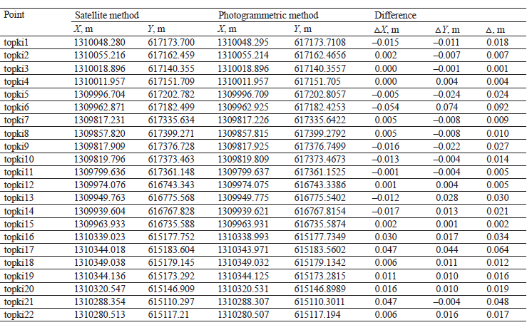

Table 2 demonstrates that the difference between the data obtained by satellite mapping and cartometrics was bigger than in the previous case and reached 25 cm. However, this MSE also stayed within the maximal allowable values. Therefore, the cartometric method proved sufficiently accurate, if compared to the satellite imagery, which served as control. Table 3 compares the data obtained by photogrammetric mapping and cartometrics.
According to Table 3, the results obtained by cartometrics and photogrammetric mapping were very similar, and the MSE stayed within 25 cm. Therefore, a much cheaper aerial survey can replace traditional cadastral and geodetic works, as well as satellite imagery.
The next stage featured the Sovhoz.avi platform, which identified inconsistencies in the available data on agricultural land plots. The analysis involved software and visual control of data using the feature point coordinates of the land plots. The analysis of the data provided by the Federal Service for State Registration, Cadaster, and Cartography showed that the Kemerovo Region has a lot of agricultural land plots with unidentified boundaries. Their area is shrinking, but very slowly.
In 2017, there were 2.44 million ha of land with undetermined boundaries. In 2020, their area decreased by 22%, shrinking to 1.90 million ha. However, the total area of agricultural lands in the Kemerovo Region is about 2.9 million ha. Consequently, 65.5% of all agricultural land has unclear plot boundaries. This situation makes land-use efficiency and business turnover impossible. Moreover, it causes conflicts as it violates the legitimate interests of land users and renders faulty taxation.
The cadastral measuring of all agricultural land boundaries in the region costs 2.7 billion rubles, or 35 million US dollars (January 2022). Land users simply cannot afford it: in 2020, the total value of commercial products produced by agricultural organizations and farms of the Kemerovo Region was about 34.9 billion rubles. Thus, land users would have to spend about 7–10% of their annual revenue on cadastral work. Obviously, they would appreciate much cheaper digital methods.
The Sovhoz.avi software also found some discrepancies in the data obtained from the Committee for State Property Management and the Ministry of Agriculture and Processing Industry of the Kemerovo Region. After 1200 paper maps were digitized, 30% of them appeared to be faulty to some extent. Figure 1 illustrates an example of such an error detected after comparing a digitized paper map with the aerial survey data.
According to the paper map provided by the State Property Management Committee, the area of the land plot was about 32 ha. According to the coordinates obtained by the photogrammetric mapping, it was about 16.3 ha. This means that the land owner has to pay almost twice as much land tax while allocating extra resources to cultivate the acres that are not there. The error triggers incorrect agricultural work planning because most indicators, e.g. yield, are initially incorrect. The error occurred as the field partially overgrew with trees and shrubs. A prompt correction will allow the farmer to plan their costs, calculate their yields, and reduce their taxes.
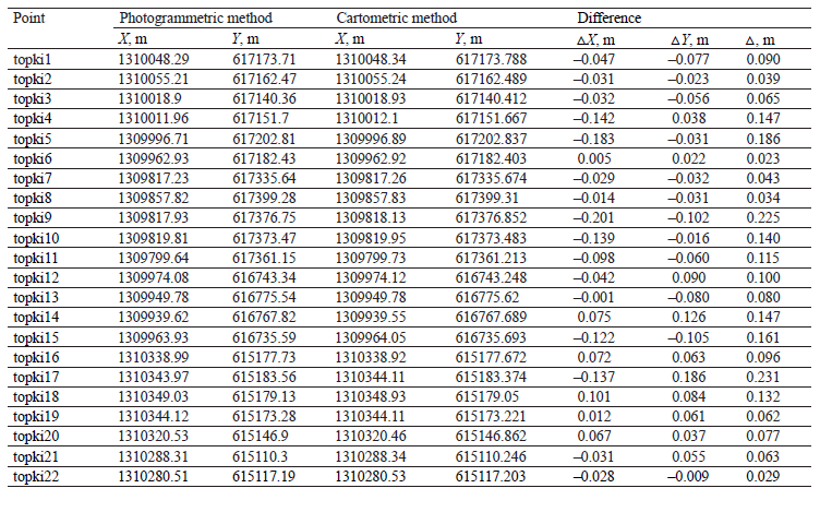
The data on all previously recorded agricultural land plots were subjected to continuous automated control. This measure corrected numerous errors found in the data provided by the authorities. In the Izhmorka municipality, the survey revealed several agricultural plots (5189 ha) on the forest fund lands. The Ministry of Agriculture and Processing Industry of the Kemerovo Region misclassified them as agricultural. Figure 2 is a Sovhoz.avi screenshot which visualizes such an error that affected an area of 2352 ha.
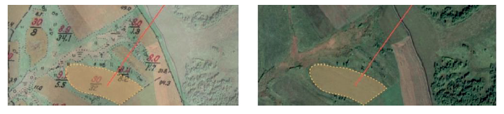
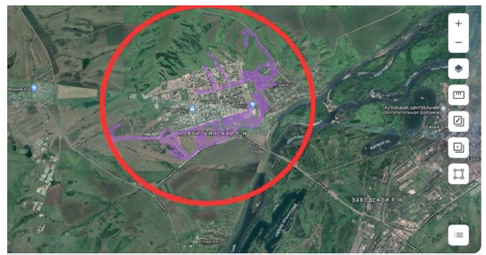
The red arrow on the left slide highlights the area that was classified as agricultural by the Ministry of Agriculture and Manufacturing Industry of the Kemerovo Region. However, the aerial survey on the right slide shows that this area is covered with forest. The data provided by the municipal authorities of the city of Novokuznetsk were subjected to similar control. The Sovhoz.avi platform identified several areas located in the city center and along the main highways that were mistakenly recorded as agricultural (Fig. 3, red circle). As a result, 670 land plots with a total area of 9144.96 ha were removed from the system.
The Sovhoz.avi platform currently contains data on 96 600 agricultural land plots with a total area of 2.4 million ha. After verification, about 0.04 million ha, which is about 1.64% of the total area, were excluded because the data were found unreliable. Since April 30, 2021, the platform has been used by the authorities and local governments of the Kemerovo Region. The users are mostly interested in such options as “view the plots”, “check and change boundaries”, and “check and change attributes”.
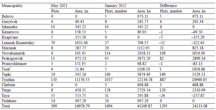
In May 2021, Sovhoz.avi was used to monitor the agricultural land use rights. Illegal use of agricultural land has become a relevant issue in the region as a result of incomplete and conflicting information, as well as a long period of no official control. Agricultural enterprises and individual farmers did not bother to obtain official permission when they decided to develop new plots, thus violating the fiscal interests of the state. In the end, farmers had neither accurate data on the size and configuration of their own lands nor any legal right to use them in transactions. The first stage of the monitoring revealed 688 plots (24 300 ha) with no official registration. While the agricultural profile of these plots was obvious from the aerial survey, the system lacked information about their state registration and permits.
Of the initially identified 688 plots, 488 plots (65.1%, 15 300 ha) proved to be charted correctly. However, 34 plots (7.6%, 1100 ha) had to be inspected by specialists. The inspections revealed that all the plots were used for farming, e.g. animal sheds, barns, etc. The farmers were sent official recommendations to register their land plots. Table 4 illustrates the changes in the number and total area of illegally used land plots in 2021–2022.
Table 4 shows that the scale of illegal agricultural land use differs from municipality to municipality. The Tyazhin municipality is responsible for about 45.4% of the total area and 68.5% of the total number of illegal agricultural land plots. Its disadvantageous location and poor transport accessibility make any control a very complicated task. In some areas, e.g. in the Krapivino municipality, almost all illegal land plots were officially registered in 2021, while in other municipalities they were identified later.
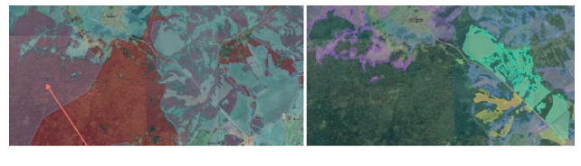
The Sovhoz.avi software can also identify unused agricultural land plots. Agricultural land-use efficiency is vital for food security and agricultural development. Unused land plots can be offered to businesses that are interested in investing in the local agriculture. Unused land plots are very different. The Sovhoz.avi platform divided them into those that are easy or hard to introduce into agricultural use. The classification was based on two criteria deduced from the digital inventory data. The first criterion was the location of the plot in relation to settlements and roads. High transportation costs make hard-to-reach areas economically unviable. Therefore, easy-to-introduce areas are located near highways and settlements (Fig. 4), where farmers can hire workers, build warehouses and garages, etc. The second criterion is vegetation. Unused land plots get overgrown with shrubs and trees. Their uprooting is not cost effective. A field with trees and shrubs is difficult and inefficient to cultivate. Sovhoz. avi can identify trees and shrubs. Figure 5 illustrates another case of an easy-to-introduce land plot in the Novokuznetsk municipality.

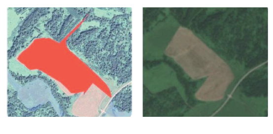
Areas with grass and trees are easy to spot (right slide) and measure (left slide, red area). The trees did not prevent Sovhoz.avi from identifying a country road that goes through the overgrown area. The monitoring revealed 3825 unused easy-to-introduce land plots with a total area of 163 400 ha and verified 1682 plots (44%) with a total area of 36 500 ha. These areas can be recorded in a separate inventory to be offered to potential investors.
Hard-to-introduce plots are far from highways and settlements. They are hard to cultivate because of trees and shrubs. Figure 6 gives an example of a hard-tointroduce land plot. The left slide shows field boundaries (highlighted) charted according to feature point coordinates. The dark green spots are trees and shrubs. The aerial survey (right slide) confirmed that the plot indeed belongs to those hard to introduce into agricultural use. It contains two birch groves, while its southern part is overgrown with shrubs. This plot would be very difficult to return to economic circulation.
The Sovhoz.avi platform revealed 29 140 hardto-introduce plots with a total area of 447 100 ha. Apparently, hard-to-introduce plots are much more numerous because all convenient plots are already in agribusiness. The platform verified 13 111 plots (44.9%) with a total area of 171 100 ha. These plots may return to economic circulation if the situation in agriculture and food market changes, e.g. prices and food demand continue to rise in 2022.
FUNDING
The research was conducted on the premises of the Research Equipment Sharing Center of Kemerovo State University (KemSU), agreement No. 075-15-2021-694 dated August 5, 2021, between the Ministry of Science and Higher Education of the Russian Federation (Minobrnauka) and Kemerovo State University (contract identifier RF----2296.61321X0032).REFERENCES
- Cooper M, Müller B, Cafiero C, Bayas JSL, Crespo Cuaresma J, Kharas H. Monitoring and projecting global hunger: Are we on track? Global Food Security. 2021;30. https://doi.org/10.1016/j.gfs.2021.100568
- Béné C, Bakker D, Chavarro MJ, Even B, Melo J, Sonneveld A. Global assessment of the impacts of COVID-19 on food security. Global Food Security. 2021;31. https://doi.org/10.1016/j.gfs.2021.100575
- Genkin AS, Mikheev AA. Influence of coronavirus crisis on food industry economy. Foods and Raw Materials. 2020;8(2):204–215. https://doi.org/10.21603/2308-4057-2020-2-204-215
- Vogliano C, Murray L, Coad J, Wham C, Maelaua J, Kafa R, et al. Progress towards SDG 2: Zero hunger in Melanesia – A state of data scoping review. Global Food Security. 2021;29(1). https://doi.org/10.1016/j.gfs.2021.100519
- Cintina V, Pukite V. Analysis of influencing factors of use of agricultural land. Research for Rural Development. 2018;1:181–187. https://doi.org/10.22616/rrd.24.2018.028
- Emran S-A, Krupnik TJ, Aravindakshan S, Kumar V, Pittelkow CM. Factors contributing to farm-level productivity and household income generation in coastal Bangladesh’s rice-based farming systems. PLoS ONE. 2021;16(9). https://doi.org/10.1371/journal.pone.0256694
- McLaughlin D, Kinzelbach W. Food security and sustainable resource management. Water Resources Research. 2015;51(7):4966–4985. https://doi.org/10.1002/2015WR017053
- Fitton N, Alexander P, Arnell N, Bajzelj B, Calvin K, Doelman J, et al. The vulnerabilities of agricultural land and food production to future water scarcity. Global Environmental Change. 2019;58. https://doi.org/10.1016/j.gloenvcha.2019.101944
- Faskhutdinova ER, Osintseva MA, Neverova OA. Prospects of using soil microbiome of mine tips for remediation of anthropogenically disturbed ecosystems. Food Processing: Techniques and Technology. 2021;51(4):883–904. (In Russ.). https://doi.org/10.21603/2074-9414-2021-4-883-904
- Drozdova MYu, Pozdnyakova AV, Osintseva MA, Burova NV, Minina VI. The microorganism-plant system for remediation of soil exposed to coal mining. Foods and Raw Materials. 2021;9(2):406–418. https://doi.org/10.21603/2308-4057-2021-2-406-418
- Bolfe ÉL, Jorge LAC, Sanches ID, Júnior AL, da Costa CC, Victoria DC, et al. Precision and digital agriculture: Adoption of technologies and perception of Brazilian farmers. Agriculture. 2020;10(12). https://doi.org/10.3390/agriculture10120653
- Shang L, Heckelei T, Gerullis MK, Börner J, Rasch S. Adoption and diffusion of digital farming technologies – integrating farm-level evidence and system interaction. Agricultural Systems. 2021;190. https://doi.org/10.1016/j.agsy.2021.103074
- Rada AO, Fedulova EA, Kosinsky PD. New method for efficiency evaluation of digital technologies in agricultural sector. Food Processing: Techniques and Technology. 2019;49(3):495–504. (In Russ.). https://doi.org/10.21603/2074-9414-2019-3-495-504
- Balafoutis A, Beck B, Fountas S, Vangeyte J, van der Wal TV, Soto I, et al. Precision agriculture technologies positively contributing to GHG emissions mitigation, farm productivity and economics. Sustainability. 2017;9(8). https://doi.org/10.3390/su9081339
- Aune JB, Coulibaly A, Giller KE. Precision farming for increased land and labour productivity in semi-arid West Africa. A review. Agronomy for Sustainable Development. 2017;37(3). https://doi.org/10.1007/s13593-017-0424-z
- Adenso-Díaz B, Villa G. Crop planning in synchronized crop-demand scenarios: A biobjective optimization formulation. Horticulturae. 2021;7(10). https://doi.org/10.3390/horticulturae7100347
- Cienciała A, Sobolewska-Mikulska K, Sobura S. Credibility of the cadastral data on land use and the methodology for their verification and update. Land Use Policy. 2021;102. https://doi.org/10.1016/j.landusepol.2020.105204
- Kocur-Bera K, Frąszczak H. Coherence of cadastral data in land management – a case study of rural areas in Poland. Land. 2021;10(4). https://doi.org/10.3390/land10040399
- Roić M, Križanović J, Pivac D. An approach to resolve inconsistencies of data in the cadastre. Land. 2021;10(1). https://doi.org/10.3390/land10010070
- Malashevskyi M, Kuzin N, Palamar A, Malanchuk M. The problems of spatial ordering and taxation of agricultural lands. Geodesy and Cartography. 2017;43(4):166–172. https://doi.org/10.3846/20296991.2017.1412634
- Lisjak J, Roić M, Tomić H, Mastelić Ivić S. Croatian LADM profile extension for state-owned agricultural land management. Land. 2021;10(2). https://doi.org/10.3390/land10020222
- García-Morán A, Ulvund S, Unger E-M, Bennett RM. Exploring PPPs in support of fit-for-purpose land administration: A case study from Côte d’Ivoire. Land. 2021;10(9). https://doi.org/10.3390/land10090892
- Feroz S, Abu Dabous S. UAV-based remote sensing applications for bridge condition assessment. Remote Sensing. 2021;13(9). https://doi.org/10.3390/rs13091809
- He X, Yang X, Luo Z, Guan T. Application of unmanned aerial vehicle (UAV) thermal infrared remote sensing to identify coal fires in the Huojitu coal mine in Shenmu city, China. Scientific Reports. 2020;10(1). https://doi.org/10.1038/s41598-020-70964-5
- Tatum MC, Liu J. Unmanned aircraft system applications in construction. Procedia Engineering. 2017;196:167–175. https://doi.org/10.1016/j.proeng.2017.07.187
- Prosekov A, Kuznetsov A, Rada A, Ivanova S. Methods for monitoring large terrestrial animals in the wild. Forests. 2020;11(8). https://doi.org/10.3390/f11080808
- Tuśnio N, Wróblewski W. The efficiency of drones usage for safety and rescue operations in an open area: A case from Poland. Sustainability. 2022;14(1). https://doi.org/10.3390/su14010327
- Mohamed N, Al-Jaroodi J, Jawhar I, Idries A, Mohammed F. Unmanned aerial vehicles applications in future smart cities. Technological Forecasting and Social Change. 2020;153. https://doi.org/10.1016/j.techfore.2018.05.004
- Montgomery K, Henry JB, Vann MC, Huseth AS, Mitasova H. Measures of canopy structure from low-cost UAS for monitoring crop nutrient status. Drones. 2020;4(3). https://doi.org/10.3390/drones4030036
- Puniach E, Bieda A, Ćwiąkała P, Kwartnik-Pruc A, Parzych P. Use of unmanned aerial vehicles (UAVs) for updating farmland cadastral data in areas subject to landslides. ISPRS International Journal of Geo-Information. 2018;7(8). https://doi.org/10.3390/ijgi7080331
- Mantey S, Tagoe ND. Suitability of unmanned aerial vehicles for cadastral surveys. Ghana Mining Journal. 2019;19(1):1–8. https://doi.org/10.4314/gm.v19i1.1
- Šafář V, Potůčková M, Karas J, Tlustý J, Štefanová E, Jančovič M, et al. The use of UAV in cadastral mapping of the Czech Republic. ISPRS International Journal of Geo-Information. 2021;10(6). https://doi.org/10.3390/ijgi10060380
- Karabin M, Bakuła K, Łuczyński R. Verification of the geometrical representation of buildings in cadastre using UAV photogrammetry. Geomatics and Environmental Engineering. 2021;15(4):81–99. https://doi.org/10.7494/geom.2021.15.4.81
- Puniach E, Kwartnik-Pruc A. The use of laser scanning and unmanned aerial vehicles in construction surveying in the light of legal regulations in Poland. Journal of Applied Engineering Sciences. 2018;8(2):79–88.
- Brookman-Amissah M, Mantey S, Kumi-Boateng B, Aikins BE, Masoud AB. Developing a workflow for the use of unmanned aerial vehicles for cadastral mapping in Ghana. Journal of Environment and Earth Science. 2021;11(2):23–31. https://doi.org/10.7176/JEES/11-2-04
